2009 Mar 19 Tonga Region Earthquake
March 27, 2009
Strong Motion Seismology Group
Can't open ./../ouyou2.cnt
Overall Comments
The March 19, 2009, Mw 7.7, earthquake occurred in the Tonga-Kermadec subduction zone
at 18:17:37 UTC time. According to the
USGS preliminary report, the earthquake hypocenter is located
in the Tonga trench region (lat = 23.050 deg. S, 174.688 deg. W, depth = 34 km)
on the interface of the Pacific and Australia plates.
The Tonga-Kermades subduction zone, extending south-southwest
to north-northeast for over 2500 km, marks the westward
subduction of the Pacific plate beneath the Australia plate.
This area is well known for its high seismic activity,
with the large number of the earthquakes having the magnitude over 6.
According to the
USGS Volcanic Activity Report, the Mw 7.7
earthquake was preceded by the eruption of the submarine volcanoes
near the Hunga Tonga and Hunga Ha'apa volcanic islands,
making part of the Tonga-Kermadec volcanic arc.
The distance between the volcanic eruption and the earthquake
is estimated to be over 200 km.
To investigate source processes of the earthquake,
we have performed teleseismic waveform inversion of Kikuchi and Kanamori (1991)
using displacement records observed at stations of FDSN from IRIS DMC.
Totally 46 vertical components of the P-wave data from the stations
with the epicentral distances of 30-100 degrees were used in the inversion.
The bathymetry of the Tonga trench indicates the need of assuming a 9 km
deep water layer for the 1D velocity structure around the source.
We fixed the epicenter determined by USGS and searched for
the focal depth to minimize the waveform fit.
The resulted best fit model corresponds to the 50 degree west-dipping thrust-fault.
This result agrees with the general features of the subducting slab geometry
in the region of the Tonga trench (see
USGS preliminary report).
Obtained slip distribution over the fault shows the existence of a single main asperity.
Significant slip reaching 6 m appears below the hypocenter at the depth of around 40 km.
The results of inversion are summarized in Fig. 2.
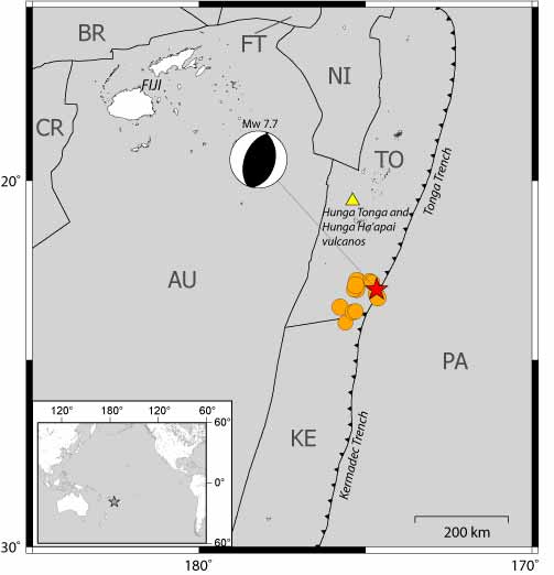
Fig. 1. Location map of the mainshock and aftershocks.
Principal tectonic features of the Tonga Region after Bird (2003).
The location of the March 19, 2009 Tonga earthquake is shown by the red star.
Orange circles corresponds to the aftershocks reported by USGS and
the yellow triangle show the location of the volcanic eruption.
Heavy black lines correspond to the plate boundaries of
the Pacific (PA), Australia (AU), Tonga (TO), Kermadec (KE),
Niuafo'ou (NI), Futuna (FT), Balmoral Reef (BR), and Conway Reef (CR) plates.
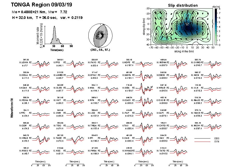
Fig. 2. Source time function, moment tensor, inverted slip, and waveform fit between the obsereved and synthetic displacements.
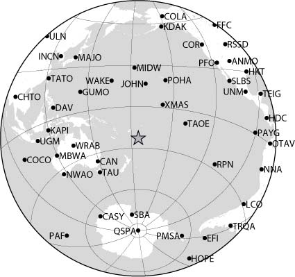
Fig. 3. Stations used for the teleseismic waveform inversion.
Link
2010 Feb 27 Central Chile Earthquake
2010 Jan 12 Haiti Earthquake
2009 Aug 09 South Off Tokaido, Japan, Earthquake
2009 July 15 Fiordland, New Zealand Earthquake
2009 Apr 06 Central Italy (L'Aquila) Earthquake
2009 Mar 19 Tonga Region Earthquake
2009 Jan 03 Irian Jaya, Indonesia, Earthquakes
2008 Nov 16 Sulawesi, Indonesia, Earthquake