2010 Jan 12 Haiti Earthquake
Launched: January 29, 2010
Updated: January 31, 2010
Strong Motion Seismology Group
An earthquake of Mw 7.1 (Global CMT Project)
occurred approximately 25 km west of Port-au-Prince,
the capital of Haiti at 21:53:10 UTC on January 12, 2010. According to the
USGS preliminary report, the event was located in the boundary region
separating the Caribbean and North American plates. The northern Caribbean
plate boundary near Haiti is dominant by left-lateral strike slip and compression accommodated
by two principal surface faults: the Septentrional fault system and
the Enriquillo-Plaintain Garden fault system, both of which are east-west trending
strike slip fault systems. According to the focal mechanism
(
Global CMT Project) and hypocenter location
(USGS)
the January 12 event corresponds to the left-lateral strike slip faulting
on the Enriquillo-Plaintain Garden fault system.
This event was a catastrophic earthquake that caused severe damage and
casualties in the Port-au-Prince area.
Nearly 170,000 people died and about three million people were affected by this event.
To investigate the source process of this earthquake, we have performed
both the the moment tensor analysis and the finite fault inversion
using the methods of Kikuchi and Kanamori (1982, 1991) and Kikuchi et
al. (2003), and the teleseismic displacement records observed at FDSN
stations from IRIS DMC. The 44 vertical components of the body-wave
data at epicentral distances of 35-100 deg. were used in the inversion
(Fig. 1). We fixed the epicenter at lat=18.457 N, lon=-72.533 E, as
reported by USGS, and search for the focal depth to minimize the waveform fit.
We used the result of the moment tensor analysis and the assumption
that the earthquake was generated by the faulting on the Enriquillo-Plaintain
Garden fault system with the east-west orientation to select the nodal
plain for the finite fault inversion (strike=259.0 deg., dip=71.0 deg.).
The fault size was assumed to be 40km x 25 km basing on the scaling
relation for inland crustal earthquakes derived by Irikura and Miyake
(2001).
The rupture initiation point was assumed to be located at a depth of
12.5 km. (Fig. 2).
In the obtained slip distribution over the fault plane, we can find a
single asperity. The peak slip of around 5.0 m appears on the upper part
of the fault plane around and above the hypocenter. The total rupture
duration is estimated to be 16 s.
The results of the inversion are summarized in Fig. 3 and the surface
projection of the obtained slip distribution is shown in the Fig. 4 together with
the aftershocks and the location of the highly damaged city of the
Port-au-Prince. According to these results, the fault slip propagated
from the hypocenter in both the
westward and eastward directions. However, the extension towards the east
(towards the city of Port-au-Prince) is predominant (Fig. 4).
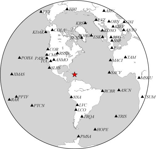
Fig.1. Stations used for the teleseismic waveform inversion.
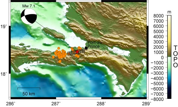
Fig. 2. Distribution of aftershocks (orange dots) and location of the mainshock (red star).
The USGS updated location of the January 12, 2010 Haiti earthquake
(red star). Orange circles correspond to aftershocks within the first
24 hours reported by USGS.
The black rectangle corresponds to the fault plane assumed for the inversion.
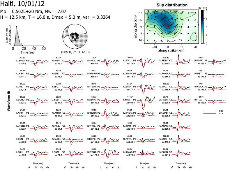
Fig. 3. Source time function, point source solution, slip
distribution, and comparison of the observed and synthetic
displacement waveforms.
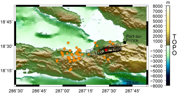
Fig. 4. Surface projection of the slip distribution superimposed on GEBCO08.
The orange circles correspond to the aftershocks within the first 24
hours reported by USGS.
Link
2010 Feb 27 Chile Earthquake
2010 Jan 12 Haiti Earthquake
2009 Aug 09 South Off Tokaido, Japan, Earthquake
2009 July 15 Fiordland, New Zealand Earthquake
2009 Apr 06 Central Italy Earthquake
2009 Mar 19 Tonga Region Earthquake
2009 Jan 03 Irian Jaya, Indonesia, Earthquakes
2008 Nov 16 Sulawesi, Indonesia, Earthquake